


Mobile AR developer Blippar has achieved a breakthrough by releasing what appears to be the first commercially-available AR navigation app.
The company's new app, AR City, gives users overlay directions for walking routes as well as points of interest. The app is available via the iOS App Store in areas supported by Apple Maps and on compatible iPhones and iPads running iOS 11.
The navigation overlays are made possible by GPS and Apple's Core Location service to determine the user's geographic position, which is supplemented using ARKit's visual inertial odometry (VIO) capabilities for tracking local movement.
AR City brings together crucial aspects of augmented reality and computer vision to transform how we experience our cities as we walk and explore. This technology will eventually replace the current map systems.
In the US, the app also applies elevation from geological surveys, so routes ascend and descend with the road. I tried the feature out briefly and found that the elevation data was a bit off. However, the app, which is still in beta, also includes the ability to adjust the position of overlays, which will help improve the accuracy of such information.
For more than 300 cities worldwide, AR City uses Blippar's own visual knowledge graph to scan the environment for visible landmarks, building on the promise brought to mobile phones by Layar, which Blippar acquired in 2014. Unlike that early version of AR, AR City applies occlusion, so points of interest obscured by buildings are not shown.
Users in San Francisco, Mountain View, and Central London will benefit from more accurate routing and location overlays, as the app will access Blippar's Urban Visual Positioning (UVP) system. Unveiled earlier this year, UVP employs computer vision to pinpoint the user's location; Blippar claims that UVP is more than twice as accurate in urban areas as GPS, which has an average error rate of 16 meters.
"The technology seamlessly combines the digital with the physical, and is a significant step in our mission to create AR natural enough that users don't feel any disconnect," said Ambarish Mitra, the CEO of Blippar, in a statement.
"What we announced today is an important breakthrough for the industry. The technology is still in its infancy, but its impact will be significant. What we are showing today with the beta version of the app is a glimpse of its potential, and we will continue to develop it, adding further features over the coming months and improving the experience."
Blippar also has plans to license the technology to other companies, particularly those in the tourism industry, where the guidebook market's estimated worth is $90 million according to the Nielsen Bookscan 2017 Travel Publishing Yearbook.
"This announcement continues to push the boundaries of augmented reality and computer vision, and opens access to technologies that have the potential to disrupt the fundamental architecture of vast location-based industries," said Mitra. "This is an opportunity for other players in the ecosystem to use our technology to take significant leaps forward in travel, autonomous transport, gaming, and many other markets."

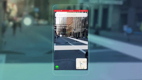
A demo from July 2017 by Blippar developer Andrew Hart shows the capability to search for a location

and then view the walking directions in AR
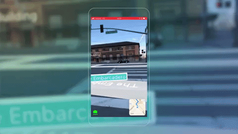
A demo from July 2017 by Blippar developer Andrew Hart shows the capability to search for a location
and then view the walking directions in AR
If this particular AR navigation dynamic looks familiar, it's because we got a glimpse of the possibilities of AR navigation courtesy of developer Andrew Hart over the summer. Not long after, Hart joined Blippar as an iOS product developer.
A Blippar spokesperson confirmed that Hart's code using ARKit and CoreLocation (ARCL) to display route overlays is included in the AR City app, along with work from other developers on the team.
It's hard to imagine that it's only been eight years since Google basically gave the world free mobile navigation by way of Google Maps for Android 2.0. At the current pace of innovation, navigating your world by looking down at a screen will seem primitive by its tenth birthday. Of course, the real value of this technology will be apparent when smartglasses are ubiquitous, when we won't need to hold a smartphone at all.
- Follow Next Reality on Facebook, Twitter, and YouTube
- Sign up for our new Next Reality newsletter
- Follow WonderHowTo on Facebook, Twitter, Pinterest, and Google+
Cover image via Blippar/YouTube


Comments
Be the first, drop a comment!